Slot Canyons

Hidden in the southeast corner of Utah down the long Hole-in-the-Rock road lies a series of canyons – tributaries to the Escalante River. Thirteen miles down Coyote Gulch takes you through a series of environmental shifts. Starting on the dry, hot and barren plateau, the trail quickly descends into a dry wash. Trees start to appear providing some nice shade and suddenly the ground is wet and water starts flowing. Sandstone cliffs begin to tower above you, shafts of sunlight stream past the rim and the riparian zone bursts into lush foliage. Tents are optional as camp can be made under the sandstone overhangs carved out by centuries of passing water. But there is little need for concern with regular sunny days and scant rainfall. Though flash floods are possible so keep an eye on the upstream weather. Click “Full Story” for more photos.

Hiking the Grand

It doesn’t matter how you access the Grand Canyon, so long as you actually get down into it. Sure, the views are impressive from the rim looking down into and along the big red gash in the earth, but it’s too big to fathom just from above. By boat or by foot, you’ve got to get into it.

Matt, Agnes and I, planned on a four day backpacking trip descending from the North Rim along the Bill Hall Trail and into Deer Creek Canyon for the first night. Well, technically our first night out was car camping on the North Rim which offered the aforementioned amazing though limited view from above. The morning sun crept down along the walls, displacing the dark pooled in the canyon as we packed up our car camp and got on the rocky trail taking us down.

NOLS Pro & Deuter Packs Trip

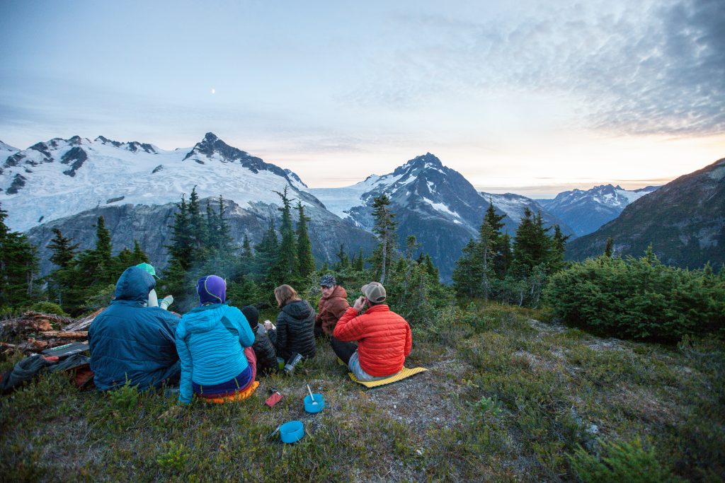
If you have been on a NOLS (National Outdoor Leadership School) trip of any sort, you know the value it provides participants with technical outdoors skills as well as the “Expedition Behavior” skills to not only get along with the members of your group but to make the trip, or expedition a resounding success. NOLS has been offering their “Pro” (short for Professional) program for a few years but are ready to ramp it up. NOLS Pro will set up a course for any professional team looking to build group dynamics, leadership, risk management and/or outdoor skills anywhere you like.

Our group was lead by two NOLS Pro instructors, Marcio Paes Barreto and Brian Fabel, who took us into the Wind River Range in Wyoming for a few days and they shared the NOLS Pro program with us. Another component included Deuter Packs as NOLS uses Deuter Packs as their robust pack rental fleet. Built to suit the rugged nature of NOLS trips, these packs are out in the field a lot and get many lifetimes of use as compared to how often a privately owned backpack gets out into the field.

Click the title above for more photos.

GEAR: Portable Power – Solar Charging on the trail

Back in 1999, I traveled to Nepal to study mountain ecology in the Himalaya. Part of our trip was a 14-day trek in the Annapurna region. Digital cameras were far from popular then, but somehow I managed to get one loaned to me. Since this was the era before proprietary rechargeable batteries the camera took a whopping four AA’s. Not knowing how fast the camera would use up the batteries and not wanting to cary a bag of AA’s along with me, I looked into rechargeable batteries and a solar charger. Looking back at where the technology was then, I’m amazed that I found a solar charger that held 4 AA batteries. So, I brought 8 batteries – 4 for in the camera and 4 to get charged in the charger that I strapped on the top of my pack to absorb the sun while we were trekking. No shortage of sunshine and the system worked great.

For a number of reasons, one being that there haven’t been many electronic items that people would need to charge on the trail, the idea of harnessing solar power while on the go hasn’t come about until fairly recently. While at the 2011 Summer Outdoor Retailer show in Salt Lake City, it’s obvious that with all the little electronic gadgets made to go on our adventures with us (cameras, GPS, iPods, lights, etc.) saving weight on batteries (not to mention the waste) has driven a number of companies to invest in providing portable solar charging options. It should also be noted these devices are not recommended for use with something as large as a laptop, but exceptions and alternatives may exist. Here’s what I found:

Ellingwood Ridge Challenge

I had the pleasure of guiding a trip in the Colorado Rockies with Mark James for the Adventure Unlimited Ranches. We took a group of intrepid adults from A/U’s Adult Base Camp (ABC) program to La Plata where the plan was to traverse Ellingwood Ridge. The five of us (two guides and three adult campers) camped at the base of the western ridge. The next morning we made it up the western ridge to the 14,334-foot summit where a batch of my mom’s home made oatmeal chocolate chip cookies were delivered. That was a treat. Once rested at the summit one camper opted to turn back and was accompanied by Mark while the rest of us started our descent along Ellingwood Ridge. This is not a trail and is a technical route. About an hour into the traverse we realized the best idea was to turn back to the summit instead of continuing on along the ridge all the way down as planned.

Exit Glacier

Finally, I made it to Alaska. For some, it’s hard to believe that I had never made it to our northern most, largest and most remote state. After being up there for two weeks poking around, it was hard to think about leaving.

My first adventure was a bit impromptu. I drove the Steward Highway and found myself going on a day-hike along side of Exit Glacier. The notable point however being that I was carrying a backpack with overnight equipment. There was a rumor of a small storm shelter somewhere up there near the Harding Icefield. Nevertheless, I was prepared to camp in the snow or tundra or on the rocks if need be.

Just rounding the bend in the road and catching your first glimpse of the glacier is impressive. A huge tongue of white rests in the steep hold of rocky ridges on either side. The base of the glacier tapers to a gentle rounded point, constrained by the gray piles of lateral moraines. A cloudy gray river flows out from the blue cave and twists through the ever changing channels of the broad outwash field that resembles a broad riverbed. In a way, it was once a river bed, for a river of ice. The glacier is indeed flowing down, but the terminus is steadily moving closer and closer to its source. Along the road and the trail leading right to the toe of the glacier are year markers showing how far down the river valley the white tongue used to reach.

Click “Full Story” below or the title above to read the rest and see the video.