Slot Canyons

Hidden in the southeast corner of Utah down the long Hole-in-the-Rock road lies a series of canyons – tributaries to the Escalante River. Thirteen miles down Coyote Gulch takes you through a series of environmental shifts. Starting on the dry, hot and barren plateau, the trail quickly descends into a dry wash. Trees start to appear providing some nice shade and suddenly the ground is wet and water starts flowing. Sandstone cliffs begin to tower above you, shafts of sunlight stream past the rim and the riparian zone bursts into lush foliage. Tents are optional as camp can be made under the sandstone overhangs carved out by centuries of passing water. But there is little need for concern with regular sunny days and scant rainfall. Though flash floods are possible so keep an eye on the upstream weather. Click “Full Story” for more photos.

Hiking the Grand

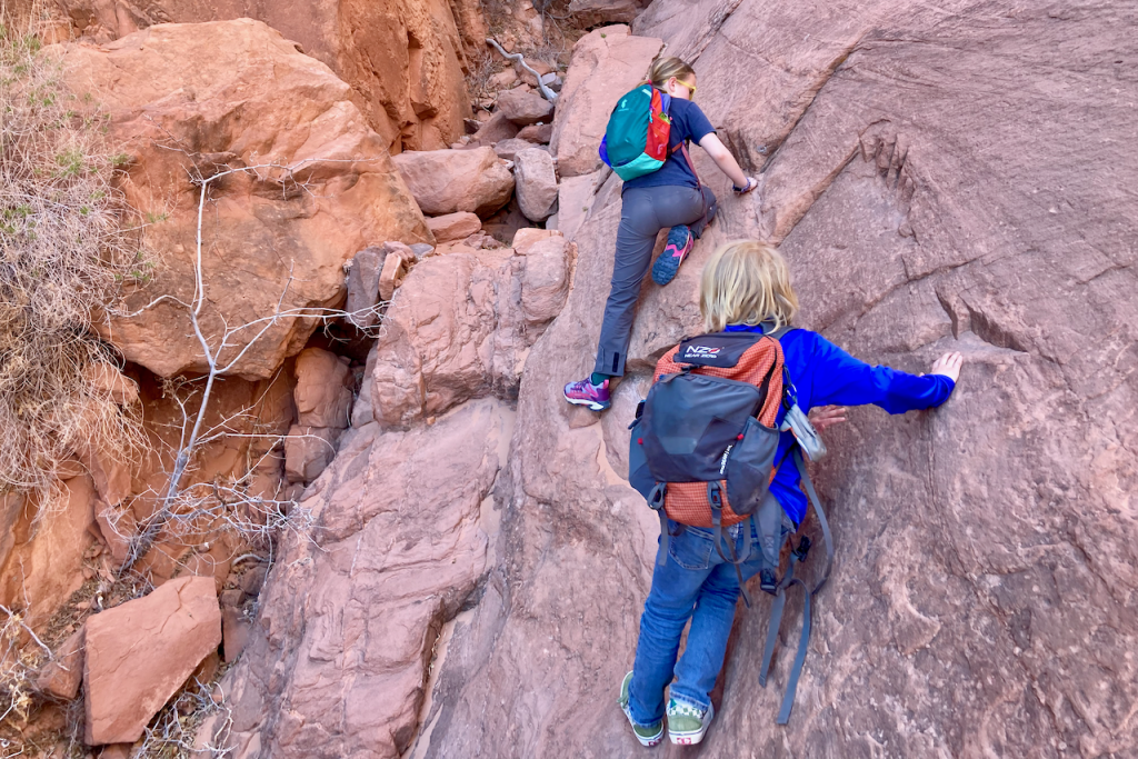
It doesn’t matter how you access the Grand Canyon, so long as you actually get down into it. Sure, the views are impressive from the rim looking down into and along the big red gash in the earth, but it’s too big to fathom just from above. By boat or by foot, you’ve got to get into it.

Matt, Agnes and I, planned on a four day backpacking trip descending from the North Rim along the Bill Hall Trail and into Deer Creek Canyon for the first night. Well, technically our first night out was car camping on the North Rim which offered the aforementioned amazing though limited view from above. The morning sun crept down along the walls, displacing the dark pooled in the canyon as we packed up our car camp and got on the rocky trail taking us down.

Ellingwood Ridge Challenge

I had the pleasure of guiding a trip in the Colorado Rockies with Mark James for the Adventure Unlimited Ranches. We took a group of intrepid adults from A/U’s Adult Base Camp (ABC) program to La Plata where the plan was to traverse Ellingwood Ridge. The five of us (two guides and three adult campers) camped at the base of the western ridge. The next morning we made it up the western ridge to the 14,334-foot summit where a batch of my mom’s home made oatmeal chocolate chip cookies were delivered. That was a treat. Once rested at the summit one camper opted to turn back and was accompanied by Mark while the rest of us started our descent along Ellingwood Ridge. This is not a trail and is a technical route. About an hour into the traverse we realized the best idea was to turn back to the summit instead of continuing on along the ridge all the way down as planned.

Exit Glacier

Finally, I made it to Alaska. For some, it’s hard to believe that I had never made it to our northern most, largest and most remote state. After being up there for two weeks poking around, it was hard to think about leaving.

My first adventure was a bit impromptu. I drove the Steward Highway and found myself going on a day-hike along side of Exit Glacier. The notable point however being that I was carrying a backpack with overnight equipment. There was a rumor of a small storm shelter somewhere up there near the Harding Icefield. Nevertheless, I was prepared to camp in the snow or tundra or on the rocks if need be.

Just rounding the bend in the road and catching your first glimpse of the glacier is impressive. A huge tongue of white rests in the steep hold of rocky ridges on either side. The base of the glacier tapers to a gentle rounded point, constrained by the gray piles of lateral moraines. A cloudy gray river flows out from the blue cave and twists through the ever changing channels of the broad outwash field that resembles a broad riverbed. In a way, it was once a river bed, for a river of ice. The glacier is indeed flowing down, but the terminus is steadily moving closer and closer to its source. Along the road and the trail leading right to the toe of the glacier are year markers showing how far down the river valley the white tongue used to reach.

Click “Full Story” below or the title above to read the rest and see the video.

River Geology

My Uncle Eddie has been rafting for many, many years. I remember when I was young, doing 15 miles down the Santiam River (san-tee-AM), a tributary of the Willamette River in Western Oregon with him and a bunch of our family. Well, since then, I’ve started joining him on more trips and have been helping him guide trips.

Atlas Trans-Sierra Snowshoe Trek

The Sierra has truly been blessed this year with record snow fall. So, although the weather this spring and early summer has been warm, there is still plenty of snow in the beautiful backcountry. With that in mind, some colleagues at Atlas Snow-Shoe Company came up with the wild idea to do a traditional skiing route across the Sierra-Nevada mountain range on snowshoes. While this was admittedly for our own personal fun, we could justify it as a work trip to test the snowshoes.

The result was a 45 mile trek across the breadth of the Sierra. We started just east of Independence, off Highway 395, and hiked up Symmes Creek. After 12,000 feet of vertical gain and traveling and camping for six days above 11,000 feet, we arrived at the Wolverton Ski Area in Sequoia National Park. The route is usually done on skis with a few mountaineering sections to get over the highest passes, including Milestone Col on the Great Western Divide at over 13,000 feet.