 There may be two routes to approach hiking up Mount Whitney, but as far as I’m concerned, there’s really only one way to go. Come from the west, my boy.
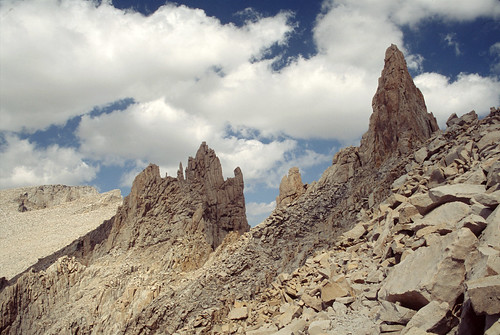
The highest peak in the lower 48 has been developed into a very straight forward hike up to the 14,496 foot summit. I say hike, not climb, in respect for those who really do climb Mount Whitney. The term ‘climb’ needs to be reserved for those who take the Mountaineering trail up to Iceberg Lake, then proceed to place protection and belay each other to climb up the hand over hand 5.7 eastern face. It’s not a hard climb, but it is a true climb, and not the hike that the masses do.
These masses pour in from all over and park at the Whitney Portal and head up the 8.5-mile trail. Permits flapping wildly on the back of their packs in the stiff breeze, give roughly 200 people a day access to the eastern approach and the summit. Some do it in a day, or 5-7 hours even. Most take a more sensible approach and hike up to one of the camps along the way, spend the night between 10-12,000 feet to acclimate, then push on to the summit with a light day pack to the summit. Few depart in the wee dark hours of the early morning to make the summit for sunrise. Others depart as the sun rises, leaving their tent and sleeping bags as colorful spots on and among the light tan ground and rocks. These tents make up the tent city of High Camp, which was somewhat of an eyesore as my party hiked down this way after approaching from the pristine wilderness on the west side and spending the night on the summit.
Carolyn and I started from a parking lot just ten miles as the crow flies southeast of the popular Whitney Portal in Horseshoe Meadows. Starting at 9,500 feet we worked our way west on a trail popular with the horses across the dry and dusty flats. It made me think now normally we pull our boots from the closet and dust them off. If this case, I was dusting them on. The sparse clustering of living and dead Ponderosa Pine provided little shade, but it didn’t really matter as the altitude kept the air cool and dry. The flat walking went for two miles when we hit a steady mile of switchbacks leading up to Cottonwood Pass at 11,000 feet. Heading up the switchbacks, we stayed in the protection of a moderate ravine and the trees got somewhat thicker. With the added effort of going up, the shade was most welcome.
 Cottonwood Pass offered a great view of Horseshoe Meadows and the slope we had just come up. Beyond the pass lay an open meadow and more mountains beyond that. Our track now turned north as we undulated along the west side of the ridge and hiked along the Pacific Crest Trail (PCT) past Chicken Spring Lake. After climbing back out of the deep Chicken Spring Lake cirque, we hovered along the 11,400 foot contour through various cirques and over a few small ridges until we finally descended into a small valley where the New Army Pass trail joined the PCT.
Night was nearly upon us and we found a nice grassy spot along the edge of a narrow meadow protected by a small grove of trees. The sun had set, but there was just enough twilight for me to drop my pack and dash off to find a good place to set a bear-bag line. When I got back, Carolyn had a nice hot cup (well, Nalgene bottle actually) of hot tea ready for me and the water continued to boil to cook dinner. She had also laid out our tarp and bivy-sacks. We were all set for a great night of sleeping under the stars at 11,000 feet.
The tea and dinner provided for a satisfying warm glow in our bellies. After brushing our teeth and hanging the bear-bag, it felt so great to finally lay down in our warm sleeping bags after the eight mile and 3,000 vertical foot day. We could hear the cool breeze rush through the trees around us. On occasion the cool wind would dip down and nip at our faces, our only exposed bare skin.
We slept so well. With our stocking caps and sleeping bag hoods pulled over our eyes, we didn’t even notice the just past full moon pass over head, or in the sky getting lighter from the glow of dawn. We were up and going by the time the sun crested over the ridge line above us. Back on the trail we had to turn west again to go around Joe Devel Peak and Mount Chamberlin. The trail took us through thick woods and along some amazing mountain meadows over to Rock Creek. There is a ranger station at Rock Creek, and we wandered down the twisted trail to the small cabin, but the ranger was out on patrol. We made use of the chairs around the outside of the cabin and had a little snack next to the babbling brook while soaking up the sun sneaking past the canopy above.
Once we finally got going again, we started another climb up to Guyot Pass. The climb was much steeper than I had expected. Then I realized the contour interval on my map was 200 feet! So, we marched up to the pass and onto Guyot Flat.
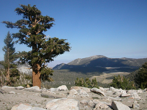
Guyot Flat, is a sparse and dry west facing basin. Even with Mount Guyot to the southwest, the direct exposure to the prevailing winds sucks the moisture right out of the ground and most of the few trees that remained were dead. The thick trunks of the dead Bristlecone Pine (Pinus longaeva & aristata) had been stripped of their thick protective bark The once tender interior now had a well weathered golden glow about them and contrasted against their red-brown barked living counterparts. The dead trees continue to be sculpted and polished by the wind and weather that is known to whip through the Inyo National Forest of the high Sierra. Some of them looked to me like giant squid, their exposed roots like a mass of tentacles holding the branch-less and wind tapered trunk to the earth. Others were gnarled and twisted into corkscrew and various other forms from the constant winds.
 Fortunately, the weather was pleasant and calm as Carolyn and I tramped along Guyot Flats. It was nearly 3pm when we dropped some elevation into the lush Crabtree Meadow and peeled off the trail along Whitney Creek. We were due for a wash, and our feet were ready for a soak in the cool water. After our rinse, we laid out in the warm afternoon sun to dry off and our bodies would shiver gently with each light breezy gust that worked its way up the valley.
Then came the discussion of our summit strategy. We were keen to get up early and catch the sunrise on the summit somehow. Our first plan was to hike up to Guitar Lake (11,400 feet) now, rest the remainder of the afternoon and evening and leave for the summit around 3am. But we were pretty tired after the 18 miles and 6,600 vertical feet we had hiked over the last two days. Another possibility that came to us was to delay for a day and just stay right here at Crabtree Meadows for the night. Then continue with the same schedule discussed earlier, resting at Guitar Lake. That made for a bit more time than we had planned, but it was what we were comfortable with. That is, until we met Max and his crew who told us about their plan to stay at Crabtree tonight then to hike to and sleep on the summit! Little did we know there was a small hut at the summit and we could have both the sunset and the sunrise.
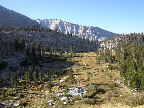
Speaking of sunsets, the one at Crabtree Meadows was spectacular. As the sun got lower and closer to sneaking behind the Red Spur ridgeline, the long red beams cast a wonderful glow on Mount Chamberlain looming above us to the southeast. There was a forest fire way to the south and the smoke muted some of the red glow, but the next morning the sky had cleared and the alpenglow on Red Spur was stunning. Sunbeams started to pour in from between Mount Chamberlain and Mount Hitchcock as we continued up Whitney Creek and the lush riparian meadows it supports. The tree stands were thick along the edges of the meadows and we were now on our final approach into the western basin below Mount Whitney.
As the trees started to thin out, the majestic peaks of Young, Hale, Russell, and Hitchcock started to enclose around us. Buy the time we got to Timberline Lake, Mount Whitney had stepped out in full view. Although the true summit couldn’t be seen from this approach, it was very encouraging to have our goal laid our before us.
Slowly, the grass carpet of the meadows started to thin out into tufts, and the long early morning beams of sunlight dappled across the patchy grass and made the water in the brook that continued beside us sparkle. Just as the trees gave way to the patchy meadows with our constant altitude gain, so the thin meadows finally gave away to the barren lands of jagged fields of granite rocks. As we continued to move west, the sun was to our right and would glisten on the smooth surface of the rocks.
We stopped at Guitar Lake to stock up on water. This was our last water source for the next 24 hours. We still had 2,000 vertical feet to gain to the summit, two water intense meals to cook and another 2,000 vertical feet to come down the next morning. In all we had about a gallon of water each. It proved to be plenty. We even had some to share with other hikers who had very little left by the time they reached the summit.
 Beyond Guitar Lake, the serious ups started. We turned south and were now marching up the switchbacks on the west side of Mount Whitney. The immense Mount Hitchcock and its daunting ragged ridgeline, jagged flying buttresses, deep crags, and huge talus cone piles paralleled along side to us. At one point we could hear the evidence of a rock slide, but couldn’t see it hidden in one of the deep grooves along Hitchcock’s broad side.
Come lunch time, we stopped where there was a little jog in the trail, and provide a bit more width than the rest of the narrow catwalk-esque track. The wind was cold and constant. Our synthetic t-shirts were good while we were climbing, but the body demanded more layers once we stopped and wolfed down a few PB&J tortillas. Tucked away in the cracks of the steep rock, a splash of purple and yellow pokes out as a few hardy flowers hold on for dear life on a small patch of protected soil.
The next segment put us at Trail Crest Junction at 13,500 feet. It was like Grand Central Station. Most of the people had come up the popular approach from the east and were on their way back down from the summit. There was one other party who had come up the western side as we had. And bless one of them, Greg, who had a spare set of 3-volt batteries because the set in my SLR camera had decided to die the evening of the first day.
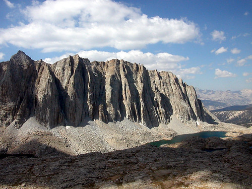
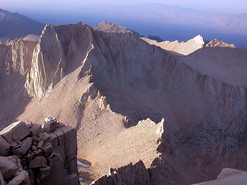
From the junction we still had 1.6 miles and just over a thousand feet to gain. The trail had few switchbacks and the grade was moderate as we hiked north just below the western ridge leading up to Mount Whitney. We passed Muir Peak and there were a few places where the ridge dipped down to the trail giving us our first glimpses of the eastern valleys and peaks. We finally crested onto the summit around three o’clock. The sun was bright and the wind was calm. High patchy clouds and active winds aloft would put eastward drifting blobs of shadows on the ragged terrain all around us. The contrast between light and dark only accentuated the dramatic ups and downs. From the top, Lone Pine peak is just to the south, Iceberg lake straight down off the eastern face (remember the 5.7 climb), and looking back west we can now see over the once looming, now dwarfed, Mount Hitchcock.
As the day moved on, and the sun started to get close to the horizon, the slow flow of visitors to the summit continued to diminish. We again watched the sun set behind Red Spur, and now that we were higher, the more distant and bigger Kaweah Peaks Ridge provided the majority of the texture to the silhouette of the jagged horizon. The wind started to pick up and we retreated into the small hut to cook dinner. As we were finishing up, we were surprised to see three more hikers come up, bounding over the rocks in the early dusk light. At first we were a bit concerned, as the hut would just fit the five of us. Then we noticed they didn’t have any packs with them as they hit the summit and turned to head back down. We didn’t envy the dark descent ahead of them.
 As the orange and red glow of the set sun faded and gave way to darkness, the pristine view of the stars started to take over. We hunkered down in our little hut for the night and the thin air of 14,500 feet made for a long night for all of us. I felt tired, but after lying there for two hours, I couldn’t fall asleep. I was using my Crazy Creek chair as a sleeping pad and finally opted to clip it back into a chair and try to sit up for a while. Oh, what I would have given for a book! Always take a book. The change in position was a welcome adjustment but of little help. The next morning I found out I wasn’t the only one having trouble. We all tossed and turned throughout the night, jockeying for position as the five of us abreast barely fit between the narrow walls of the small hut.
Around 10.30 that evening, the door of the hut suddenly swung open. I had laid back down by then and only noticed the flash of a head lamp as whoever poked in surveyed the full hut. The door shut again and my oxygen deprived half asleep brain wondered what the heck that was and wrote it off as one of the five of us who had gotten up to go to the bathroom. A few hours later, our visitor, Nick, returns and under his breath says that he has to squeeze in. Carolyn and I sit up and welcome him in. She tells him he should have come on in the first time. Nick continues to comment that he hiked 40 miles to get here and only has a 40 degree bag!
The rest of the night faded away to a fitful half sleep for me. At one point I did have to get up for a visit with mother nature. I reached up and pressed against the ceiling to gingerly balance myself past the tightly packed semi-sleeping bodies. When I made it to the door I stepped out to the blinding glare of the moon. The light granite of the summit magnified the reflection of the four-day waning gibbous moon. The wind was still howling from the west, and the stars were bright and clear regardless as the moon glare infested the sky making it more grey than black. I knew it was pretty late, as Orion (a winter constellation) was high in the sky. But my bare-chested, naked feet, exposed body demanded focus be kept on the task at hand.
It wasn’t hard to re-warm my sleeping bag and I zoned out for the most part until morning. Carolyn had set her alarm for 5am so we could be up to see the sunrise. She started rummaging around and realized it was 6am! We must have all been out when it went off. We scrambled and got up and out to the still windy summit and were just half an hour ahead of the sun peaking up from the horizon. The sunrise seemed to take much longer than the sunset, but it was worth the wait, along with the three or four folks who hiked up from High Camp early that morning.
After we had our fill of the sunrise and cold wind, we mustered back in the hut to start boiling tea and to get some breakfast. Some of the morning hikers joined us and we slowly packed our gear and started to head down. It was pretty easy going and we had to stay pretty well bundled up until we crested over the ridge at Trail Crest to the east side where we got out of the wind and into the morning sun as it continued to beat down on us and warmed us pretty quickly. I was just glad I was going down and not among the nearly 100 people slogging up the estimated 96 switchbacks. As we got closer to and beyond High Camp, we started seeing the trailside lost and found. There was a key on a chain, a pair of shorts, a few sets of insoles, and a rag (or something?) on a rock along the creek.
The whole seven and some odd miles down from Trail Crest to Whitney Portal just felt over populated and again the thought of hiking against the flow was one I appreciated as I thought back on our four-day backcountry approach to the highest peak in the lower 48. We finally meandered our way down the last set of switchbacks and into the Whitney Portal Shop where the rumor of a great burger awaited us.
